|
North Fredericksburgh Township,
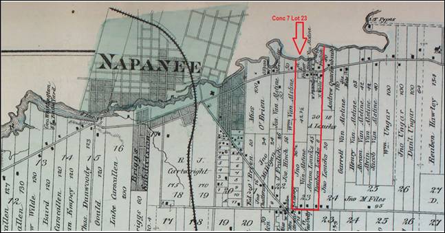
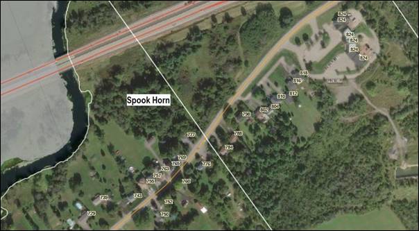
Concession 7 Lot 23 The Crown deed for the property
was granted to Gaspar Bower on December 31, 1798. Most likely a burial ground for
the early settlers in Clarkesville and surrounding area. There are no visible signs of a
cemetery. |
|
North
Fredericksburgh Township, Concession 7, Lot 23 Meacham’s
Atlas 1878 |
|
North
Fredericksburgh Township, Concession 7, Lot 23 Google
Maps 2025 |
|
Burying Ground Found Near Napanee Its Origin is Unknown New Owner Discovers Slabs of Limestone July
8, 1963, Kingston Whig Standard When Ivan Simkins bought eight acres of Lot 23 Concession 7, in North
Fredericksburgh Township five years ago, he had already heard the rumor that
the property contained an Indian burying ground. The rumor, hard to pin down, was, at first, of little interest to the
new owner. The property, with frontage on the Palace road and the Napanee River,
slopes gently from road to river. A point of land extending into the river
perhaps accounts for the name by which the property has been known to
children of the area for generations – Spook Horn. Lot 23, North Fredericksburgh, like many other lots along the Palace
Road, dates back to the earliest settlement of Loyalist days. On several of
the old deeds, the property transfer was recorded: “With the exception of
nine square feet for the late Frank Vanalstyne.” No mention was made however,
where Frank Vanalstyne rested. In the community, it is said that Mr. Vanalstyne’s remains were exhumed and buried elsewhere. But rumors of the Indian
burying ground still remained. The new owner found [no] remains, except those of generations of neglect,
until he finally reached the lower slopes of his property with his power
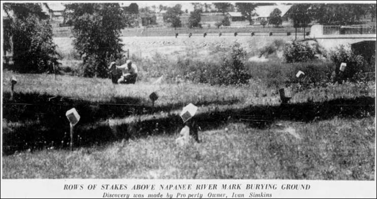
mower. (There are now five acres cut by mower.) He made a discovery, a bit of an unpleasant one; his power mower kept
hitting stones. Expecting to find ordinary field stone, he tried pulling one out. The stone
was limestone, though there is no limestone outcrop on the property and none
closer than the hill above, which at its eastern end is known as Roblin Hill. The stone refused to budge. Digging disclosed that it extended far
into the ground. It was a vertical slab of limestone, with only a few inches showing
above the ground. This experience was repeated with disheartening regularity. To save
his mower Ivan Simkins drove stakes in at each stone. When the whole area was cleared he made the discovery that the stones
were in rows. There were thirty-four in all. Meanwhile, a little above the “burying-ground,” he found more stones,
field stones arranged in a plumb line as though forming the outline of a
foundation. Asparagus grows at what may have been a doorstep. What is the secret beneath the rows of limestone slabs, planted
vertically, like grave markers? Certainly the limestone must have been
carried from a distance, for no limestone exists in this gouged out valley. A stone’s throw away is the bridge over Highway 401. Engineers dug
down 75 feet before they found the stone required in the contract for the
foundation of their bridge. If the limestone marks graves, are they Indian graves? It is hardly
likely, unless Christian Indians, for Indians did not mark the resting place
of their dead in this way. If not Indian, then are they white men’s graves, explorers’ or fur
traders? Champlain is known to have
explored a river in the vicinity. Was it the Napanee river? Could he, in a
skirmish with Indians, have lost some men, buried them here, marking their
graves so that others later chose the same burying ground? Did fur-traders searching for rich harvest in the valley suffer loss
of men from scurvy, from smallpox and bury them here? |
|
|
|
|
|
Archeologist Digs in Old Cemetery May
26, 1964, Kingston Whig Standard A Palace Road couple has a mystery on its hands. Part of the large, rolling riverside property which belongs to Mr. and
Mrs. Ivan Simpkins in North Fredericksburgh Township has turned out to be an
unknown cemetery. Who is buried there? How many? How old is the cemetery? Why is there
no record of a cemetery there? These are just a few of the puzzling question which the Simpkins would
like answered. According to an eminent archaeologist, Dr. Walter Kenyon of Toronto,
the cemetery may contain the remains of the first settlers who came to this
area around 1786 when a man named Clark founded a mill and settlement on the
Napanee River. The settlement became known as Clarksville, now the oldest and
most historic section of Napanee. Mr. Simpkins first discovered the unknown cemetery while cutting grass
last summer. His mower kept running against flat stones which would not budge
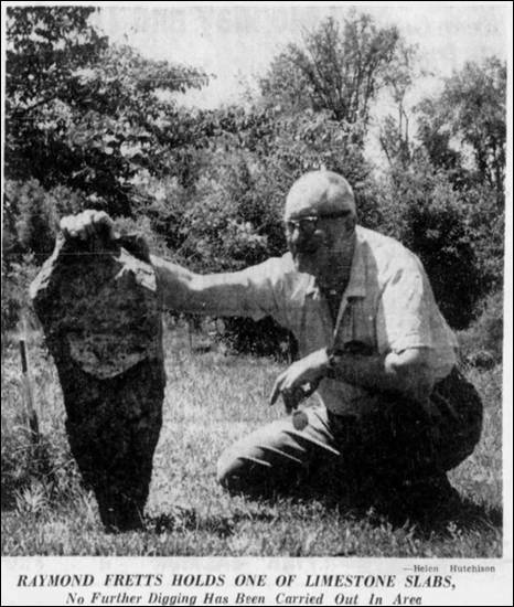
when he tried to pull them out. His curiosity piqued, he dug out several stones and discovered they
were two to three feet long slabs of uncut limestone. Since they were
arranged in a pattern, he surmised they must have marked graves. He dug up three of the graves and found skeletons but nothing either
in the graves or on the uncarved limestone slabs to
identify the remains. Perplexed, he turned to the Lennox and Addington Historical Society
for help. The society persuaded Dr. Kenyon, assistant curator of the royal
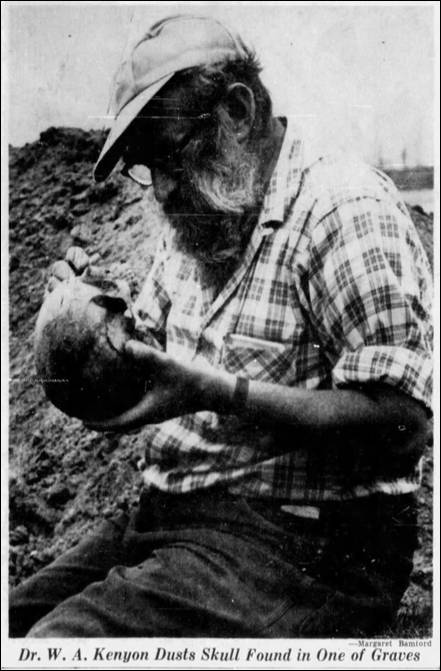
Ontario Museum in Toronto, to come to Napanee and try to solve the mystery. Dr. Kenyon began exploratory digging May 11 but by May 14, after he
had dug up four graves, he, too, was mystified. He was certain of two facts, however. The cemetery was not an Indian
burial ground and it was not the long-sought Sulpician
mission which was believed to have been situated in this area around 1669. He also concluded it was not a family burial plot since he estimated
it contained at least 50 or more graves. This he determined by the number of
limestone slabs there. In a recent interview, the bearded archaeologist explained that the
skeletons were not those of Indians. They were white Europeans, three female
and one male, possibly in their 20s when they died. The presence of female skeletons ruled out the cemetery as the Sulpician mission burial ground, he said. Dr. Kenyon, who said he could find no record of a cemetery at this location commented: “People keep
track of their burial grounds. Why didn’t the community here keep track of
this one – particularly a cemetery of this size?” The archaeologist, who has been with the Royal Ontario Museum for the
past 10 years, took the skeletons back to Toronto for further study. In a written report on the exploratory excavating, received Thursday
by Mrs. Helen Hutchison, historical society secretary, Dr. Kenyon said he had
concluded the cemetery “Must have been founded shortly before 1786 when
Clarke founded the first mill on the Napanee River.” The Palace Road cemetery predates other old cemeteries in the Napanee
area, he reported after taking a “cursory” tour of the burial grounds. The earliest
cemetery for which records are available dates back to 1840 and it contains
engraved tombstones. “We conclude that the Palace Road cemetery is associated with the
village of Clarkesville and was abandoned sometime prior to 1840,” he wrote. A copy of Dr. Kenyon’s report has been filed with the department of
public records in the government archives. The historical society is expected to continue the investigation into
earlier records predating 1864, which are kept in the Kingston registry
office, in an effort to find some record of a cemetery at that location. |
|
|